Monday, January 27, 2014
Winter finally returns!
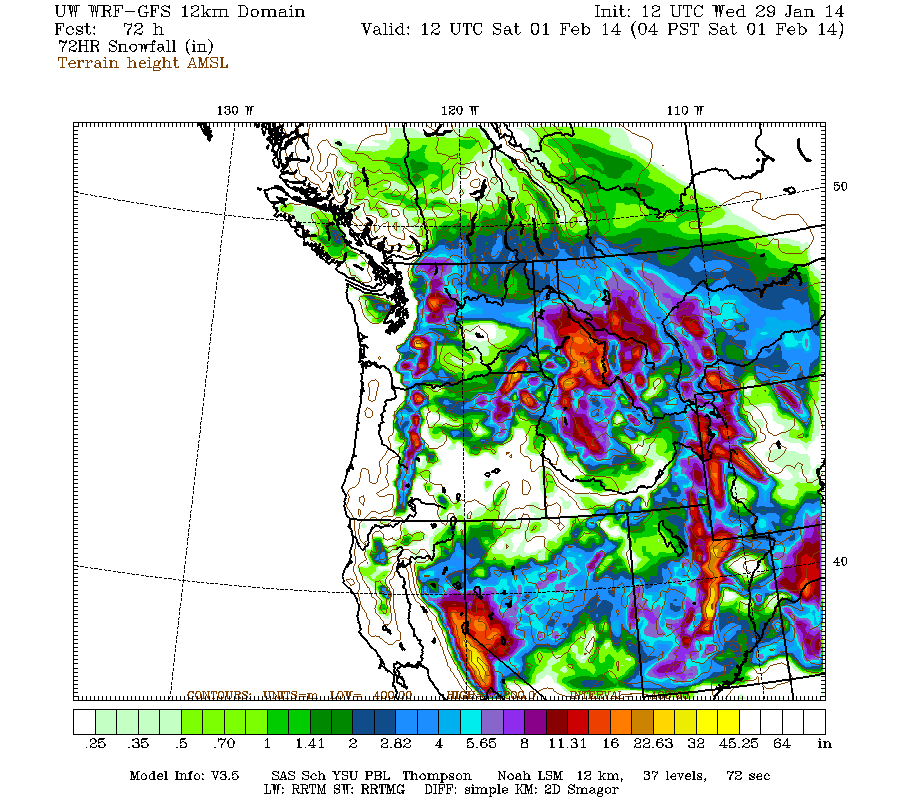
A storm (warm front initially) is finally expected to move into Utah on Wednesday and continue into the day on Friday, most of the snow arrives early on Thursday with the cold front in northern Utah then the front stalls over central/southern Utah on Friday with clearing in northern Utah. As of now plan on a general 10-20" of snow for most central and northern Utah mountains above 8,000 ft with 4-8" in the southern Utah mountains. Click on the below map for details.


Monday, January 20, 2014
Utah Snow Cover
Click on the below satellite picture to see the snow cover over Utah on January 20th.

Friday, January 17, 2014
February Outlook

Saturday, January 11, 2014
Last storm
Once more storm is forecasted to move into mainly northern Utah on Saturday night with snow continuing at times into Monday morning. In general plan on a trace-3" in the Wasatch front valleys, 2-5" for the benches, 5-8" for the mountain valleys, and 8-18" for the mountain areas above 7,000 ft. Click on the below image for WRF model forecasted snow for this storm.

Tuesday, January 7, 2014
Series of storms
Three storms are forecasted to move through mainly northern Utah through Friday morning with the strongest storm arriving on Thursday, another possible storm on the weekend. In general plan on 2-4" of snow for the Wasatch Front valleys, 4-6" benches and mountain valleys, 6-12" for the Wasatch mountains above 7,000 ft. Enjoy the new snow!
Click on the below image for WRF model forecasted snow through 5am on Friday.

Click on the below image for WRF model forecasted snow through 5am on Friday.
Wednesday, January 1, 2014
Thursday, December 26, 2013

Friday, December 20, 2013
Round 2
Another storm is forecasted to move into Utah on Friday night and continue through the day on Saturday, a few light snow showers/flurries lingering into Sunday. Plan on 1-2" for most western Utah Valleys, 2-3" benches, 3-8" for most areas above 6,000 ft, local 8-10" for favored mountain locations.
See below for model projected snowfall for this storm.

See below for model projected snowfall for this storm.

Thursday, December 19, 2013
January Outlook
Looks like warmer than normal weather for Utah in January with near normal precipitation. These forecasts are typically just ok and I would say only correct 60% of the time in Utah.


Wednesday, December 18, 2013
Finally a little snow is on the way!
We finally have a storm for Utah after 11 days of dry weather! Look for rain/snow/freezing rain to develop late Friday evening over Utah and continue into the day on Thursday, mostly ending by dark. Plan on a general 6-10" of snow for the central/southern Wasatch/Uinta/Wasatch Plateau above 7,000 ft, 2-6" northern Wasatch and southern Utah mountains. Very tricky forecast for the valleys with the cold air trapped near the surface, otherwise it would be rain for the valleys. Depending on your valley location you will see rain/snow/freezing rain, most accumulating valley snow looks to fall north of the point of the mountain. See below map for model projected snowfall for the storm.


Subscribe to:
Posts (Atom)