-32 this morning at Peter Sinks Utah, Peter Sinks is near Logan summit.
http://www.wrh.noaa.gov/mesowest/getobext.php?sid=PSINK&banner=gmap&raw=0
Saturday, December 29, 2012
Friday, December 28, 2012

Tuesday, December 25, 2012
More snow
Another storm is expected to bring more snow to the entire state focused
between 5am Wednesday and 5am Friday. Plan on 2-4" for the Wasatch
Front valleys, 4-8" benches and many western valleys of central/southern
Utah, 6-10" for the Wasatch mountain valleys and many areas between
6,000 and 8,000 ft, 10-20"+ for many mountain areas above 8,000 ft. Click below map for model projected snowfall through 5pm on Friday. Enjoy the snow!


Sunday, December 23, 2012
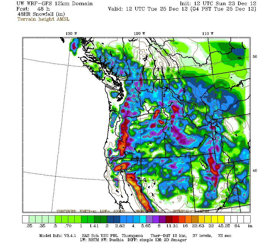
White Christmas
Plan on snow for the Wasatch front valleys and mountains focused between 8pm Sunday and 8pm on Monday. As of now plan on 1-3" for the valleys, 3-6" for the benches, 4-8"+ for areas between 5,500' and 7,500', and 8-16"+ for the mountains above 7,500'. Below picture is the model projected snowfall through 5am on Christmas.

Friday, December 21, 2012

Wednesday, December 19, 2012
Cold!
It was -44 this morning at Peter Sinks in Utah! http://www.wrh.noaa.gov/mesowest/getobext.php?sid=PSINK&banner=gmap&raw=0 Go to http://twdef.usu.edu/Peter_Sinks/Sinks.html to read more about Peter Sinks which is located near Logan Summit.
Monday, December 17, 2012
Last in the series
The last and strongest piece of the series of storms is forecasted to move through northern Utah today and tonight clearing out of the Wasatch front around 9am on Tuesday. The last piece of the storm has sped up so snowfall will be a little less than expected but still plan on another 6-16" for the Wasatch and Uinta Mountains to go along with the 8-20" that has fallen since 5pm Saturday. Total snow since 5pm Saturday in the 14-36" range by 9am on Tuesday.
Saturday, December 15, 2012
Series of storms!
A series of storms is expected to bring 30-40"+ of snow to the northern Utah mountains above 7,000 ft between 5pm Saturday and 5am on Wednesday! Click on the links to the right so see the model projected snow fall. Enjoy!
Thursday, December 6, 2012
Cold storm
A cold winter storm is expected to move into northern Utah on Saturday and continue into Sunday morning with generally light snow showers in the valleys, light to moderate in the mountains. Will need to watch for lake effect on Saturday night into Sunday morning south of the Great Salt Lake. As of now plan on tr-1" for the valleys/benches with local 2-4" south of the Great Salt Lake, 3-6" for the mountains.
Wednesday, December 5, 2012
Small storm
Plan on 3-8" of snow for the northern Utah mountains above 8,000 ft with the storm moving through today that lingers into tonight. Valley rain.....
Saturday, December 1, 2012
Small quick moving storm
Plan on 4-9" of snow in the northern Utah mountains on Sunday afternoon/evening as a quick moving storm moves through.
Subscribe to:
Posts (Atom)