New Focus
Friday, December 1, 2023
Saturday, June 10, 2023
Record heat in Salt Lake City?
Here we go again with more record heat for the official Salt Lake City airport (KSLC) observation location. Salt Lake City is setting record heat at a much faster rate than other locations in Utah for the reasons below.
The current airport location has undergone significant changes in ground cover since it was installed in 2010. In September 2011 (see below image) it was a grassy/weedy area with less pavement/buildings around, the observation site now (see May 2023 image below) is surrounded by dirt/gravel with more buildings/pavement encroaching on the site. Nothing can be done to eliminate the urban heat island effect which is one reason for the warmer temperatures. The second and likely bigger reason for the warming temperatures is the change in ground cover directly around KSLC which something could be done about.
For how 2 meter temperatures are affected by ground cover check out this article https://www.scielo.org.mx/scielo.php?script=sci_arttext&pid=S0187-62362008000200002 that includes a comparison (article 3.2) of the 2 meter air temperatures on 15 calm, sunny, dry days. The study looked at the air temperature difference over three different surface types including asphalt/concrete, soil, & grass. This study can directly relate (but not as dramatic) to what is going on at KSLC on sunny light wind days with the change in ground cover around the station changing from a weedy/grassy area to dirt/gravel area.
Sunday, April 30, 2023
Alta ski season snowfall record!
The Alta ski season (October 1st-April 30th) snowfall record of 748" from the 1981-1982 season has been destroyed and replace by 903" from the 2022-2023 season! This record is from the Alta Collins study plot at 9662' in elevation.
Thursday, April 6, 2023
Utah Snow Water Equivalent is 214% of Normal
Here is today's Utah statewide snow water equivalent (30.0" which is a record) chart and basin map which might be the peak for the year.
Wednesday, April 5, 2023
Alta snow depth record!
On April 5th 2023 Alta hit its all time snow depth record of 248"! The previous record was 236" on May 19th 1983.
Saturday, April 1, 2023
Utah Snow Water Equivalent is 196% of Normal.
Looking at the above chart is shows an average of 28.0" of snow water equivalent from all of the SNOTEL stations around Utah which is a record!
Friday, March 31, 2023
Alta snowfall record?
With all of the snowfall record talk this year at Alta I wanted to clarify things a little due to some confusion. The all time Alta ski resort record for snowfall has been smashed (800"+ and counting) this year with one month to go. The Alta ski resort snowfall season includes all snowfall between October 1st and April 30th at the Collins study plot which is at 9662' in elevation.
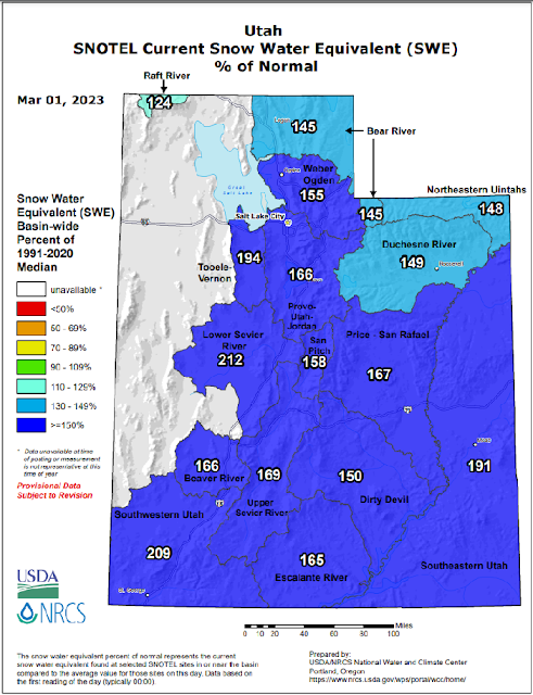
Wednesday, March 1, 2023
Wednesday, February 22, 2023
Possible new Utah low pressure record!
Looking at the below Vernal airport observations from today it looks like the 28.94" Hg (980 mb) could be a new Utah State record for the lowest pressure ever recorded!
Go to https://mesowest.utah.edu/cgi-bin/droman/meso_base_dyn.cgi?stn=KVEL&unit=0&timetype=LOCAL for current/past Vernal data.
Wednesday, February 1, 2023
Monday, January 30, 2023
Peter Sinks
Peter Sinks in Utah (near Logan summit) has hit -62F this morning! Link to the current temperature at http://weather.gov/wrh/timeseries?site=PSINK The on-minute average low occurred between the 15 minutes observations listed. This is the lowest temperature recorded in Utah since -62F at Middle Sinks (very close to Peter Sinks) on January 30th 2002.
Peter Sinks is a natural sink hole at 8,164 feet in elevation, it is about 1/2 mile in diameter. Cold air sinks at night and pools into this natural sink hole making it much colder than nearby areas, also no one lives there. On February 1st 1985 Peter Sinks was -69.3F which is the record low for Utah. More information about Peter Sinks at https://climate.usu.edu/PeterSinks/index.php


