Look for near normal precipitation for all of Utah in April, near normal temperatures in northern Utah with above normal temperatures in southern Utah.
New Focus
I'm now mostly a retired meteorologist but still love to watch Utah weather. I will continue to update the Utah weather cam images and Utah weather links pages and occasionally post Utah weather related information. I'm spending more time enjoying Utah snow skiing, cycling, hiking, and water skiing.
Friday, March 31, 2017
Thursday, March 30, 2017
Wet pattern continues (41)
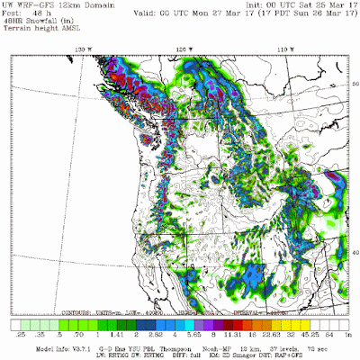
The wet weather pattern continues with another storm moving into Utah on Thursday, lingering showers into Friday evening. Click on the below map for the WRF forecasted snow through 6am on Saturday.
Monday, March 27, 2017
Friday, March 24, 2017
Wednesday, March 22, 2017
Finally back in a wet pattern (38)
After a long break of very warm and dry weather we finally have a storm that moves into Utah today, showers mostly end by dark on Thursday. Look for valley rain with falling mountain snow levels. Plan on a general 5-10" (local 11-18") of snow for the northern Utah mountains above 8,000 ft, 3-8" for the southern Utah mountains and northern areas between 6,000-8,000 ft. Click on the below map for the WRF model forecasted snow between 6am Wednesday and 6am on Friday.
Sunday, March 5, 2017
Strong Cold Front (37)
A strong cold front will push through Utah Sunday afternoon/evening with any rain quickly changing to snow with most lover valley snow only lasting for a few hours, lingering snow showers over and near the mountains through Tuesday morning. Plan on a general 8-14" (local 15-24") snow for the northern Utah mountains above 8,000 ft, 3-8" for the southern Utah mountains and mountain valleys. In the lower valleys/benches look for 1-5" of snow. Click on the below map for the WRF model forecasted snow between 5am Sunday and 5am Tuesday.
Wednesday, March 1, 2017
Subscribe to:
Comments (Atom)


