
Saturday, February 28, 2015
Warmest and least snowy winter on record for SLC!
Winter 2014-2105 (December 1st-February 28) will go down as the warmest and least snowy on record for Salt Lake City and much of the state. Click on the below map for December 1st-February 28th temperature anomaly.
Friday, February 27, 2015
Second of three storms. (20)
The second of the three storms moves into Utah on Friday night and is anticipated to continue through Monday night with most of the rain/snow staying in central/southern Utah, third storm on Tuesday not looking as promising as yesterday. Plan on a general 2-6" (local 7-10") for the central/southern valleys above 4,500 ft with 8-18" (local 18-24") for the mountains above 8,000 ft. In northern Utah look for tr-1" valley snow mainly for areas south of the point of the mountain, a general 4-10" for the Wasatch mountains south of I-80 and the Uinta's. Click on the map below is the WRF model forecasted snow between 5pm Friday and 5pm Monday.

Thursday, February 26, 2015
First of three storms! (19)
The first of three storms will move through mainly northern/central Utah today and continue into Thursday night, looks dry on Friday. A second storm is expected to move into the state on Friday night and continue through early Monday that will mainly bring wet weather to central/southern Utah. The third storm is forecasted to move into the state on Monday night and continue through Wednesday morning. WRF model forecasted snow for the first storm is below. In general plan on 0-trace in the valleys, 1/2-2" benches and mountain valleys, 2-5" for mountain areas above 7,000 ft with the first storm.

Saturday, February 21, 2015
Downslope winds
Look for downslope winds to develop on Saturday night and continue through the day on Monday, winds peaking early on Monday morning. Plan on general 20-30 mph winds with gusts to 45 mph in the prone downslope areas, local 45 mph steady winds with gusts to 65 mph centered near Centerville/Farmington. Below map are the forecasted winds as of 1am on Monday.

Friday, February 20, 2015
Snow returns to mainly southern Utah (18)
Look for generally light scattered snow showers mainly over the mountains of northern Utah on Friday and Saturday, a heavier band of widespread snow is expected to set up over central/southern Utah on Saturday night and continue into the morning hours on Monday then decrease and pull out of the state on Monday afternoon. Plan on 0-2" for the northern Wasatch front valleys/benches with 1-4" (local 4-8") for the central/northern Wasatch mountains. In southern Utah plan on a general 3-6" (local 6-12") of snow for most valleys above 4,000 ft with 8-16" (local 16-24") in most mountain areas above 8,000 ft.

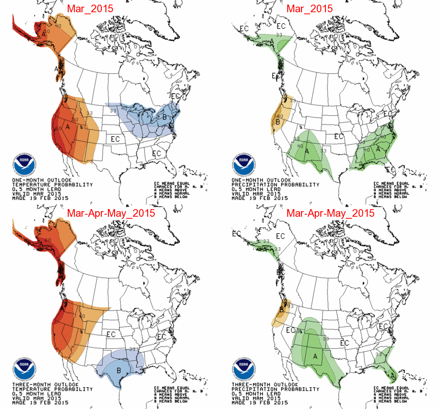
March Outlook
Plan on above normal temperatures in all of Utah for March with above normal precipitation for the south and east areas, near normal precipitation in the north and west areas.
Monday, February 9, 2015
Another small storm (17)
Plan on 1-4" of snow for the northern Utah mountains above 8,000 ft today. See below WRF model forecasted snow through 5am Thursday.

Monday, February 2, 2015

Sunday, February 1, 2015
Unsettled, three storms (16)
Look for the first and weakest storm to move through northern Utah on Sunday night into Monday morning, a little stronger system on Monday night into Tuesday morning, and the third system on Tuesday night into Wednesday morning. All three storms are expected to bring some valley rain with snow mostly staying above 6,000 ft. Plan on a general 4-14" of snow for the central/southern Wasatch and Uinta moutnains above 7,000 ft with 6-16" for the northern Wasatch. See below for the WRF model forecasted snow through 5pm Wednesday.

Subscribe to:
Posts (Atom)